Francis Chichester's Festival of Britain & Other London Maps & Guides
- Peter Berthoud
- Oct 4, 2023
- 5 min read

In 1947 Francis Chichester first published his "Heart of London" pictorial map as a jigsaw and a folding map. In 1951 the map was greatly expanded in scope and was reused in different guides for decades.

Francis Chichester's original 1947 Heart of London map covered a small and very central area. Click on that map, right, for my previous post.
In 1951 the map was greatly expanded and went on sale as Chichester's Picture Map of London - Festival Edition.
The new Festival Edition map covered a far greater area than the 1947 map, it now showed the whole of central London from the Zoo in the North, The Oval in the South, Earls Court in the West and a chunk of St Katherine Docks in the East.
Chichester's Picture Map of London - Click on any panel for a larger view.


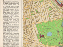


Unlike the 1947 map, the new map was printed on both sides enabling Chichester to include far more information and all the additional maps that a visitor would require.
CHICHESTER'S
PICTURE MAP OF LONDON
FESTIVAL EDITION

"Comprises: Pictures of 230 buildings and monuments of interest or importance on a map printed in 6 colours covering 22 square miles of London Streets
Short descriptions of 50 main places of interest to a visitor. A cross-referenced index of 4,200 streets with separate indexes of monuments, places of interest and principal buildings, theatres, cinemas, and main road exits from London.
A second street plan and indexes for embassies, High Commissioners, principal shops and business houses, hotels, restaurants, and railway stations. This plan shows the bus routes.
A plan and index of the underground network."
Whilst The 1951 map was not an "Official" Festival product, it did include the key structures at the Festival of Britain's main site on the South Bank.

Chichester's Picture Map of London - Festival Edition
Detail of the South Bank, The Dome of Discovery, Skylon and The Royal Festival Hall.
Chichester's Picture Map was updated and reissued for the Coronation in 1953. But by the late 1950s the folding map format appears to have been completely abandoned in favour of small pocket diary sized versions.

This is a late 1950s copy of Chichester's Map & Guide of London, its plain red cloth cover and its index page. The map's extent is the same as the Picture Map but now spread over 40 pages. In addition to the map there are over 30 pages of additional information.
Below are two pages of the map, the palette is different to that used on the original Picture Map but otherwise only small revisions have been made.

On the South Bank, The National Film Theatre is in the building that was the Telekinema during the Festival of Britain and the nearby Shot Tower is still standing.
Chichester's Map & Guide of London was revised and republished frequently throughout the early 1960s and beyond. None of the editions were dated so a close look at the maps and the accompanying information is required to give an approximate date. Often, even within a single edition, the map and the guide information were produced at different times. Perhaps unsurprisingly the information sections appear to have been updated more frequently than the maps.
In May 1967 Francis Chichester became internationally famous for his record-breaking, solo, circumnavigation of the globe. 250,000 people gathered to watch him complete his 226 day long challenge as he returned to Plymouth Harbour.
Chichester was publicly knighted at Greenwich by Queen Elizabeth II, with the same sword that Queen Elizabeth I had used to knight Sir France Drake in 1581. A commemorative stamp was issued to mark Chichester's achievement, a very rare honour at the time, especially as Chichester was not a member of the Royal Family nor deceased.
His craft, Gipsy Moth IV went on public display at St Katherine Docks in London in 1967. This is the souvenir brochure produced for that exhibition.

In 1968 Gipsy Moth IV moved to a "permanent" dry dock in Greenwich, visitors could go aboard and for many years it was a very popular attraction, she finally left Greenwich in 2005. You can read about her restoration and the plans of her new owners on their website.

Gipsy Moth IV at Greenwich circa 1969.

This is a late 1970s copy of Francis Chichester's Map & Guide of London. The cover, all gold tooled and red leatherette, now proudly bears his full name and his signature. The contents had hardly changed since the editions of the 1950s and 60s but the profile of the author certainly had. All post 1967 editions reflect this change to an extent.
Below are two pages of this guide's map, with only minor updates to earlier maps.

On the South Bank, Jubilee Gardens have replaced most of the Festival of Britain site. Queen Elizabeth Hall & The Hayward Gallery have been added, The National Film Theatre has moved to the space under Waterloo Bridge and the Shot Tower is no more.
Sir Francis Chichester died on 26th August 1972 and his widow Sheila in 1989 but the Chichester Guides continued to be published well into the 1990s.
The standard guides were produced, with revisions as required, but from the late 1960s there were also numerous editions sold through contract publishing to a wide variety of businesses. Japan Airlines, Dunlop and Thorne were just a few of the larger clients who had customised versions, with a few additional pages and sometimes maps, tailored to their businesses. There were also many more editions for smaller companies with their logo simply overprinted on the front cover and a single page acting as a bound compliments slip.
In addition to the versions designed to be used as corporate gifts, two other Chichester guides are worth mentioning: London Man and London Woman. Both these titles were essentially identical in content to the regular Chichester guides but each included a few extra pages of mutually exclusive appeal.
To give a flavour of their style and focus, here are their introductions:
Francis Chichester's London Man | Shelia Chichester's London Woman |
With this guide you can be as knowledgeable about the most elegant masculine city in the world as if you had lived in London all your life. It collects together the kind of information which a man who is a stranger to London is unable to get from any other source. In book form it is the advice of a sophisticated and experienced man who knows London well and is in a position to advise you where you can get the best of everything you are likely to need, be it a nightclub entertainment or a hair-cut, a hire car, a new suit or a dish of oysters. | This is the information every woman wants when she arrives in a city she does not know very well. It is not the information she will get from a hall-porter, however well informed, for how can he tell her the best place to look for a pretty cocktail dress, or where to get her hair done in a hurry? It is not the information she can glean from advertisements, or even shop windows. It is the sort of information she would get from a really good woman-friend, who knows her way round the shops, the stores and the beauty-parlours. |
London Man and London Woman were also repackaged at various times as A Man's Guide to London, A Woman's Guide to London, Sheila Chichester's London Fashion Guide and Francis Chichester's Guide to Good Living in London.
The longevity of Chichester's map is remarkable, essentially the same map served Londoners and visitors from 1947 to at least 1999. Of all the different versions my favourite is the Festival Edition folding map, one day I will get around to having my copy framed. The smaller pocket-sized guides are full of interesting snippets on restaurants, clubs and places of interest, they are relatively inexpensive and fairly easy to find, especially if you don't mind the odd annotation and a few dog-eared pages.
Many other, very different, pictorial maps of London were produced during the 20th century, there is an expert round-up of some notable examples in a blog post by Tim Bryars on the Bryars & Bryars website. If you pop into the Bryars' shop in Cecil Court you can probably see, and no doubt covet, some beautiful originals.


